
Borghetto d'Arroscia
| Borghetto d'Arroscia comune tagliáne | |
|---|---|
  | |
 | |
| Localizzazione | |
| State | |
| Reggione | |
| Provinge | |
| Amministrazione | |
| Sinnache | Angela Denegri (lista civica Uniti per Borghetto) da 'u 4-10-2021 |
| Date de istituzione | 1861 |
| Territorie | |
| Coordinate | 44°03′26.57″N 7°58′54.31″E |
| Altitudine | 155 m s.l.m. |
| Superficie | 25,94 km² |
| Crestiàne | 393[1] (28-2-2023) |
| Denzetà | 15,15 ab./km² |
| Fraziune | Gavenola, Gazzo, Leverone, Montecalvo, Ubaga, Ubaghetta |
| Comune 'nzeccate | Aquila d'Arroscia, Caprauna (CN), Casanova Lerrone (SV), Pieve di Teco, Ranzo, Vessalico |
| Otre 'mbormaziune | |
| Cod. postale | 18020 |
| Prefisse | 0183 |
| Fuse orarie | UTC+1 |
| Codece ISTAT | 008009 |
| Cod. catastale | A993 |
| Targhe | IM |
| Cl. sismiche | zone 3 (sismicità vasce)[2] |
| Cl. climatiche | 1483 |
| Nome javetande | borghettini |
| Patrone | san Marco Evangelista |
| Sciurne festive | 25 abbrìle |
| Cartografije | |
 Borghetto d'Arroscia  Borghetto d'Arroscia | |
.svg) | |
| Site istituzionale | |
Borghetto d'Arroscia (jndr'à 'u ligure U Burghettu) éte 'nu comune tagliáne de 393 crestiáne jndr'à provinge de 'Mberie.
Sciugrafije
[cange • cange 'a sorgende]Storie
[cange • cange 'a sorgende]Monuminde e luèche de inderesse
[cange • cange 'a sorgende]Suggettate
[cange • cange 'a sorgende]Culture
[cange • cange 'a sorgende]Sciugrafije antropeche
[cange • cange 'a sorgende]Economije
[cange • cange 'a sorgende]Infrastrutture e trasporte
[cange • cange 'a sorgende]Sport
[cange • cange 'a sorgende]Amministrazione
[cange • cange 'a sorgende]Culture popolare
[cange • cange 'a sorgende]Gallerie fotografeche
[cange • cange 'a sorgende]-
 Chiesere de San Marche
 -
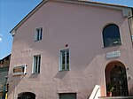 'U Municipio
 -
 'A frazione de Gavenola
 -
 'A frazione de Leverone
_01.jpg)

.jpg)
_-_panor%C3%A0mma_de_Lever%C3%B3n_(2).jpg)
Note
[cange • cange 'a sorgende]- ↑ Dato Istat - Popolazione residente al 28 febbraio 2023 (dato provvisorio).
- ↑ (IT) Classificazione sismica (XLS), su rischi.protezionecivile.gov.it.
Collegamiènde fòre da Uicchipèdie
[cange • cange 'a sorgende]- Sito ufficiale, su comunediborghettodivara.net.
- Borghétto d'Arròscia, su sapere.it, De Agostini.
Otre pruggette
[cange • cange 'a sorgende] Uicchimedie Commons tène files multimediale sus Borghetto d'Arroscia
| Condrolle de autorità | VIAF (EN) 244778097 · GND (DE) 7637274-1 |
|---|
Categorije:
- Stub
- P625 lette da Uicchidate
- Prefisso telefonico locale letto da Wikidata
- Codice ISTAT letto da Wikidata
- P41 lette da Uicchidate
- P94 lette da Uicchidate
- P281 lette da Uicchidate
- P395 lette da Uicchidate
- P806 lette da Uicchidate
- P856 differende sus Uicchidate
- P2044 lette da Uicchidate
- P2046 lette da Uicchidate
- P856 letta da Wikidata
- P6706 letta da Wikidata
- Comune d'a Liguria
- Comune d'a provinge de Imperia
- Pàggene cu le mappe