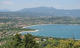
Manerba del Garda
Aspetto
| Manerba del Garda comune tagliàne | ||
|---|---|---|
 | ||
| ||
| State | ||
| Reggione | ||
| Provinge | ||
| Coordinate | 45°33′00″N 10°33′00″E | |
| Altitudine | 130 m s.l.m. | |
| Superficie | 28 km² | |
| Crestiàne | 3 751 | |
| Denzetà | 134 cr./km² | |
| Fraziune | Balbiana, Crociale, Gardoncino, Montinelle, Pieve Vecchia, Solarolo | |
| Comune 'nzeccate | Moniga del Garda, Polpenazze del Garda, Puegnago sul Garda, San Felice del Benaco, Soiano del Lago | |
| CAP | 25080 | |
| Prefisse | 0365 | |
| Codece ISTAT | 017102 | |
| Cod. catastale | E883 | |
| Nome javetande | manerbesi | |
| Site istituzionale | ||
Manerba del Garda éte 'nu comune tagliáne de 3.751 crestiáne.
Categorije:
- Stub
- Prefisso telefonico locale uguale a Wikidata
- Codice ISTAT uguale a Wikidata
- P94 assende sus Uicchidate
- P281 uguale sus Uicchidate
- P806 uguale sus Uicchidate
- P856 differende sus Uicchidate
- P2044 lette da Uicchidate
- P2046 differende sus Uicchidate
- Comune d'a Lombardia
- Comune d'a provinge de Brescia
- Pàggene cu le mappe

