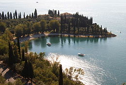
Garda (comune)
Aspetto
| Garda comune tagliàne | ||
|---|---|---|
 | ||
| ||
| State | ||
| Reggione | ||
| Provinge | ||
| Coordinate | 45°34′00″N 10°43′00″E | |
| Altitudine | 67 m s.l.m. | |
| Superficie | 16,11 km² | |
| Crestiàne | 3 802 (01-06-2007) | |
| Denzetà | 236 cr./km² | |
| Fraziune | nessuna | |
| Comune 'nzeccate | Bardolino, Costermano, Manerba del Garda (BS), San Felice del Benaco (BS), Torri del Benaco | |
| CAP | 37016 | |
| Prefisse | 045 | |
| Codece ISTAT | 023036 | |
| Cod. catastale | D915 | |
| Nome javetande | gardesani | |
| Patrone | Assunzione di Maria | |
| Sciurne festive | 15 agosto | |
| Site istituzionale | ||
Garda éte 'nu comune tagliáne de 3.594 crestiáne.
Categorije:
- Pagine con argomenti di formatnum non numerici
- Stub
- Prefisso telefonico locale uguale a Wikidata
- Codice ISTAT uguale a Wikidata
- P18 lette da Uicchidate
- P94 assende sus Uicchidate
- P281 uguale sus Uicchidate
- P806 uguale sus Uicchidate
- P856 differende sus Uicchidate
- P2044 uguale sus Uicchidate
- P2046 differende sus Uicchidate
- Comune d'u Veneto
- Comune d'a provinge de Verona
- Pàggene cu le mappe

