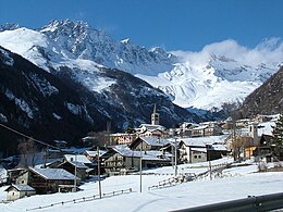
Ollomont
Aspetto
| Ollomont comune tagliàne | |||
|---|---|---|---|
 | |||
| |||
| State | |||
| Reggione | |||
| Provinge | |||
| Coordinate | 45°51′00″N 7°19′00″E | ||
| Altitudine | 1 356 m s.l.m. | ||
| Superficie | 53 km² | ||
| Crestiàne | 160 (01-01-2007) | ||
| Denzetà | 3 cr./km² | ||
| Fraziune | Balme, Barliard, Bas, Calpey, Capoluogo, Chante', Chez-Collet, Cognein, Creton, Croux, Fontane, Glassier, La Cou, Morion, Rey, Vaud, Vesey, Vevey, Voueces Dessous, Vouèces Dessus. | ||
| Comune 'nzeccate | Bagnes (Svizzere), Bionaz, Bourg-Saint-Pierre (Svizzere), Doues, Etroubles, Oyace, Valpelline. | ||
| CAP | 11010 | ||
| Prefisse | 0165 | ||
| Codece ISTAT | 7046 | ||
| Cod. catastale | G045 | ||
| Nome javetande | ollomontesi o ollomontois | ||
| Site istituzionale | |||
Ollomont éte 'nu comune tagliáne de 160 crestiáne.
Valle d'Aosta Comune d'a Provinge de Aosta
| Allein · Antey-Saint-André · Aosta · Arnad · Arvier · Avise · Ayas · Aymavilles · Bard · Bionaz · Brissogne · Brusson · Challand-Saint-Anselme · Challand-Saint-Victor · Chambave · Chamois · Champdepraz · Champorcher · Charvensod · Châtillon · Cogne · Courmayeur · Donnas · Doues · Emarèse · Etroubles · Fontainemore · Fénis · Gaby · Gignod · Gressan · Gressoney-La-Trinité · Gressoney-Saint-Jean · Hône · Introd · Issime · Issogne · Jovençan · La Magdeleine · La Salle · La Thuile · Lillianes · Montjovet · Morgex · Nus · Ollomont · Oyace · Perloz · Pollein · Pont-Saint-Martin · Pontboset · Pontey · Pré-Saint-Didier · Quart · Rhêmes-Notre-Dame · Rhêmes-Saint-Georges · Roisan · Saint-Christophe · Saint-Denis · Saint-Marcel · Saint-Nicolas · Saint-Oyen · Saint-Pierre · Saint-Rhémy-en-Bosses · Saint-Vincent · Sarre · Torgnon · Valgrisenche · Valpelline · Valsavarenche · Valtournenche · Verrayes · Verrès · Villeneuve |
Categorije:
- Stub
- P625 uguale sus Uicchidate
- Prefisso telefonico locale uguale a Wikidata
- Codice ISTAT differente da Wikidata
- P18 lette da Uicchidate
- P41 lette da Uicchidate
- P94 differende sus Uicchidate
- P281 uguale sus Uicchidate
- P806 uguale sus Uicchidate
- P856 uguale sus Uicchidate
- P2044 uguale sus Uicchidate
- P2046 differende sus Uicchidate
- Comune d'a Valle d'Aosta
- Comune d'a provinge de Aosta
- Pàggene cu le mappe


