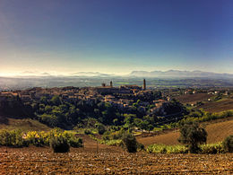
Morrovalle
Aspetto
| Morrovalle comune tagliàne | ||
|---|---|---|
 | ||
| ||
| State | ||
| Reggione | ||
| Provinge | Macerata | |
| Coordinate | 43°18′52.56″N 13°34′50.16″E | |
| Altitudine | 246 m s.l.m. | |
| Superficie | 42,60 km² | |
| Crestiàne | 10 164 (28-02-2009) | |
| Denzetà | 238,59 cr./km² | |
| Fraziune | Borgo Pintura, Cunicchio, Frati San Gabriele, Santa Lucia, Trodica | |
| Comune 'nzeccate | Corridonia, Macerata, Monte San Giusto, Montecosaro, Montegranaro (FM), Montelupone | |
| CAP | 62010 | |
| Prefisse | 0733 | |
| Codece ISTAT | 043033 | |
| Cod. catastale | F749 | |
| Nome javetande | morrovallesi | |
| Patrone | San Bartolomeo | |
| Sciurne festive | 24 agosto | |
| Site istituzionale | ||
Morrovalle éte 'nu comune tagliáne de 9.534 crestiáne.
Categorije:
- Pagine con argomenti di formatnum non numerici
- Stub
- P625 uguale sus Uicchidate
- Prefisso telefonico locale uguale a Wikidata
- Codice ISTAT uguale a Wikidata
- P18 lette da Uicchidate
- P94 assende sus Uicchidate
- P281 uguale sus Uicchidate
- P806 uguale sus Uicchidate
- P856 differende sus Uicchidate
- P2044 uguale sus Uicchidate
- P2046 differende sus Uicchidate
- Comune de le Marche
- Comune d'a provinge de Macerata
- Pàggene cu le mappe

