
File:Scotland relief location map.jpg

Dimenziune de sta andeprime: 456 x 600 pixel. Otre resoluziune: 182 x 240 pixel • 365 x 480 pixel • 584 x 768 pixel • 1 128 x 1 483 pixel.
File origgenale (1 128 × 1 483 pixel, dimenzione d'u fail: 927 KB, tipe de MIME: image/jpeg)
Riepileghe
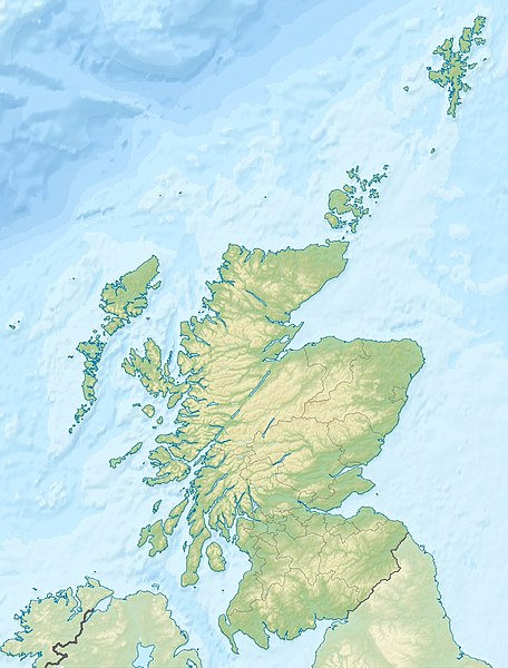
| Descrizione | Quadratische Plattkarte, N-S-Streckung 170 %. Geographische Begrenzung der Karte: * N: 61.0° N * S: 54.5° N * W: 8.8° W * O: 0.4° W Equirectangular projection, N/S stretching 170 %. Geographic limits of the map: * N: 61.0° N * S: 54.5° N * W: 8.8° W * E: 0.4° W |
| Date | (UTC) |
| Sorgende | Fatije proprie |
| Autore |
|
| Otre versiune |
|

Licenziate da
Ije, 'u titolare d'u copyright de sta fatìe, dichiare de pubblecarle sotte a le seguende licenze:
Stu file jè licenziate sotte 'a Creatività comune Attribution-Share Alike 3.0 Unported licenze
Attribbuzione: Eric Gaba, NordNordWest, Uwe Dedering
- Tu si libbere:
- da spartere – pe copià, distribbuì e trasmettere 'a fatìe
- da misckà – pe adattà a 'a fatìe
- Sotte a le condiziune seguende:
- attribbuzione – A dà le credite giuste, 'nu collegamende a 'a licenze e dicere ce onne state fatte de le cangiaminde. Puè farle accumme vuè tu, ma none jndr'à 'nu mode ca suggerisce ca 'u licenziande approve a te e l'ause tune.
- condivide cose simile – Ce tu cange, trasforme o costruisce sus a sta fatìe, tu puè destribbuì 'a fatìe ca ne iesse fore sule sotte a 'a stessa licenze o simile a queste.

|
Permesse jè garandite pe copià, distribbuì e/o cangià stu documende sotte a le termine d'a Licenze GNU Free Documentation, Versione 1.2 o versione cchiù nuève pubblecate da Free Software Foundation; senze le Seziune Invariande, senze Front-Cover Texts, e senze Back-Cover Texts. 'Na copie d'a licenze jè ingluse jndr'à sezione titolate Licenze GNU Free Documentation. |
Tu puè scacchià 'a licenze ca vuè.
Archivije de le carecaminde origgenale
This image is a derivative work of the following images:
- File:Scotland_location_map.svg licensed with Cc-by-sa-3.0, GFDL
- 2008-10-09T18:27:35Z NordNordWest 1128x1483 (829918 Bytes) {{Information |Description= {{de|Positionskarte von [[:de:Schottland|Schottland]], [[:de:Vereinigtes Königreich|Vereinigtes Königreich]]}} Quadratische Plattkarte, N-S-Streckung 170 %. Geographische Begrenzung der Karte: *
Uploaded with derivativeFX
cunde
Cazze sus 'na date/orarie pe vedè 'u fail a cumme asseva jndr'à quidde timbe.
| Sciurne/Orarie | Thumbnail | Dimenziune | Utende | Commende | |
|---|---|---|---|---|---|
| corrende | 01:30, 26 Sci 2010 | | 1 128 × 1 483 (927 KB) | Uwe Dedering | {{Information |Description={{de|Positionskarte von Schottland, Vereinigtes Königreich}} Quadratische Plattkarte, N-S-Streckung 170 %. Geographische Begrenzung der Karte: * N: 61.0° N * S: 54.5° N * W: |
Ause d'u file
sta pàgene apponde a stu fail:
Ause d'u file globale
Le seguende Uicchi ausane stu file:
- Ause sus a ab.wikipedia.org
- Ause sus a am.wikipedia.org
- Ause sus a ar.wikipedia.org
- Ause sus a arz.wikipedia.org
- Ause sus a ast.wikipedia.org
- Ause sus a as.wikipedia.org
- Ause sus a awa.wikipedia.org
- Ause sus a azb.wikipedia.org
- Ause sus a az.wikipedia.org
- Ause sus a ba.wikipedia.org
- Ause sus a be-tarask.wikipedia.org
- Ause sus a be.wikipedia.org
Vide ause globale de stu file.