
File:Europe 1748-1766 en.png

Dimenziune de sta andeprime: 800 x 570 pixel. Otre resoluziune: 320 x 228 pixel • 640 x 456 pixel • 1 024 x 730 pixel • 1 280 x 913 pixel • 2 560 x 1 825 pixel • 3 872 x 2 761 pixel.
File origgenale (3 872 × 2 761 pixel, dimenzione d'u fail: 1,26 MB, tipe de MIME: image/png)

|
Questa immagine (categorizzazione automatica: map of europe) o tutte le immagini in questa categoria o galleria dovrebbero essere ricreate usando grafica vettoriale come file SVG. Questo offre diversi vantaggi: vedi Commons:Media for cleanup per maggiori informazioni. Se è disponibile una versione in formato SVG di questa immagine, per favore caricala. Dopo aver caricato un file SVG, sostituisci questo avviso con il template {{Vector version available|nome_immagine.svg}}.
|
_en.png)
.png)
.jpg)
Riepileghe
| Descrizione |
Deutsch: Diese Karte zeigt Europa in den Jahren nach dem Frieden von Aachen 1748 und in der Zeit des Siebenjährigen Krieges (1756-1763). Bis 1766 kam es zu keinen größeren geographischen Veränderungen in Europa.
Die Arbeit wurde mit Inkscape erstellt und beruht hauptsächlich auf einer Karte in: Putzger - Historischer Weltatlas, Berlin 1990, S.78f.
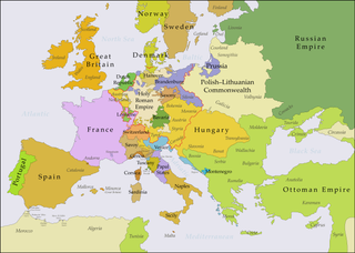
English: This map shows Europe in the years after the Treaty of Aix-la-Chapelle 1748 and the Seven Years' War (1756-1763). Europe did not see another major geographical change until 1766. The red line marks the borders of the Holy Roman Empire.
The work was created with Inkscape and is mainly based on a map in: Putzger - Historischer Weltatlas, Berlin 1990, 78 pp.
Français : Cette carte montre l'Europe dans les années après le Traité d'Aix-la-Chapelle (1748) et pendant les années de la Guerre des Sept Ans (1756-1763). L'Europe n'a pas vu un autre changement géographique important jusqu'à 1766.
Le travail a été créé avec Inkscape et il est basé principalement sur une carte dans: Putzger - Historischer Weltatlas, Berlin 1990, 78 pp.
Polski: Ta mapa ukazuje Europę w latach po pokoju w Akwizgranie z 1748 i wojnie siedmioletniej (1756-1763). Europa nie uświadczyła żadnych poważniejszych zmian geograficznych aż do 1766. Czerwona linia znaczy granice Świętego Cesarstwa Rzymskiego.
Praca została stworzona z użyciem Inkscape i powstała głównie na bazie mapy w: Putzger - Historischer Weltatlas, Berlin 1990, 78 pp.
Русский: Эта карта представляет Европу после заключения Аахенского мира в 1748 г. и во время Семилетней войны (1756-1763 гг.). До 1766 г. эта картина Европы не исменилась.
Эта работа нарисована с помощью программы Inkscape и основана на карте из книги: Putzger - Historischer Weltatlas, Berlin 1990, 78 cc. |
| Date | |
| Sorgende |
Questo file deriva da: Europe 1748-1766.png |
| Autore | P. S. Burton |
Licenziate da
Ije, 'u titolare d'u copyright de sta fatìe, dichiare de pubblecarle sotte 'a seguende licenze:
Stu file jè licenziate sotte 'a Creatività comune Attribution 3.0 Unported licenze
- Tu si libbere:
- da spartere – pe copià, distribbuì e trasmettere 'a fatìe
- da misckà – pe adattà a 'a fatìe
- Sotte a le condiziune seguende:
- attribbuzione – A dà le credite giuste, 'nu collegamende a 'a licenze e dicere ce onne state fatte de le cangiaminde. Puè farle accumme vuè tu, ma none jndr'à 'nu mode ca suggerisce ca 'u licenziande approve a te e l'ause tune.
cunde
Cazze sus 'na date/orarie pe vedè 'u fail a cumme asseva jndr'à quidde timbe.
| Sciurne/Orarie | Thumbnail | Dimenziune | Utende | Commende | |
|---|---|---|---|---|---|
| corrende | 23:48, 15 Lug 2018 | | 3 872 × 2 761 (1,26 MB) | Bryanrutherford0 | Added the Ionian Islands, made the Duchy of Milan a Habsburg possession |
| 04:29, 10 Lug 2018 |  | 3 872 × 2 761 (1,25 MB) | Bryanrutherford0 | Added Comtat Venaissin and redrew borders of Neuchâtel, Bishopric Basel, and Montbéliard | |
| 15:19, 5 Ott 2017 |  | 3 872 × 2 761 (1,25 MB) | Bryanrutherford0 | Adjusted Russian-Swedish border in Finland to reflect Russian gains in the 1743 Treaty of Åbo after the Russo-Swedish War. | |
| 02:40, 3 Ott 2017 |  | 3 872 × 2 761 (1,25 MB) | Bryanrutherford0 | Transferred control of Saaremaa and Hiiumaa to Russia (1721 Treaty of Nystad) | |
| 16:58, 30 Set 2017 |  | 3 872 × 2 761 (1,25 MB) | Bryanrutherford0 | Adjusted Russian-Swedish border in Finland to reflect Russian gains in the 1743 Treaty of Åbo after the Russo-Swedish War. | |
| 22:49, 2 Feb 2017 |  | 3 872 × 2 761 (1,26 MB) | Blowwhite1 | Fixed names | |
| 10:01, 5 Màs 2013 |  | 3 872 × 2 761 (1,25 MB) | P. S. Burton | == {{int:filedesc}} == {{Information |Description={{de|1=Diese Karte zeigt Europa in den Jahren nach dem Frieden von Aachen 1748 und in der Zeit des Siebenjährigen Krieges (1756-1763). Bi... |
Ause d'u file
Non ge stonne pàggene ca appodene a stu fail.
Ause d'u file globale
Le seguende Uicchi ausane stu file:
- Ause sus a af.wikipedia.org
- Ause sus a ar.wikipedia.org
- Ause sus a azb.wikipedia.org
- Ause sus a bg.wikipedia.org
- Ause sus a cs.wikipedia.org
- Ause sus a de.wikipedia.org
- Ause sus a el.wikipedia.org
- Ause sus a en.wikipedia.org
- Ause sus a es.wikipedia.org
- Ause sus a et.wikipedia.org
- Ause sus a eu.wikipedia.org
- Ause sus a fa.wikipedia.org
- Ause sus a fi.wikipedia.org
- Ause sus a fr.wikipedia.org
- Ause sus a he.wikipedia.org
- Ause sus a hu.wikipedia.org
- Ause sus a hy.wikipedia.org
- Ause sus a id.wikipedia.org
- Ause sus a it.wikipedia.org
- Ause sus a it.wikiversity.org
- Ause sus a ja.wikipedia.org
Vide ause globale de stu file.