
File:EU27-2008 as a single entity in the world.svg

Dimenzione de quiste PNG andeprime de quiste SVG file: 800 x 443 pixel. Otre resoluziune: 320 x 177 pixel • 640 x 354 pixel • 1 024 x 567 pixel • 1 280 x 709 pixel • 2 560 x 1 417 pixel • 999 x 553 pixel.
File origgenale (Fail SVG, nominalmende sonde 999 × 553 pixel, dimenzione d'u fail: 561 KB)
Riepileghe
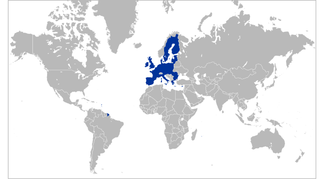
| Descrizione | Locator map for territory claimed by the European Union (EU 27) |
| Date | |
| Sorgende | Opera propria basata su: Location European Union.svg di Ssolbergj |
| Autore | Kolja21 |
| Otre versiune |
|
| SVG sviluppo | Questa mappa in grafica vettoriale è stata creata con Inkscape. |


Licenziate da
Ije, 'u titolare d'u copyright de sta fatìe, dichiare de pubblecarle sotte 'a seguende licenze:
Stu file jè licenziate sotte 'a Creatività comune Attribution 3.0 Unported licenze
- Tu si libbere:
- da spartere – pe copià, distribbuì e trasmettere 'a fatìe
- da misckà – pe adattà a 'a fatìe
- Sotte a le condiziune seguende:
- attribbuzione – A dà le credite giuste, 'nu collegamende a 'a licenze e dicere ce onne state fatte de le cangiaminde. Puè farle accumme vuè tu, ma none jndr'à 'nu mode ca suggerisce ca 'u licenziande approve a te e l'ause tune.
Archivije de le carecaminde origgenale
This image is a derivative work of the following images:
- Location European Union.svg licensed with GFDL-en
- 2008-10-18T11:51:01Z Ssolbergj 999x553 (586765 Bytes) What does that mean?
- 2008-10-18T09:07:46Z SeNeKa 940x415 (1552215 Bytes) More correctly
- 2008-10-03T21:24:30Z Ssolbergj 999x553 (586765 Bytes) UNLESS YOU READ THE EDIT HISTORY AND WRITE EDIT SUMMARIES, REVERTING = VANDALISM
- 2008-10-02T11:39:09Z SeNeKa 940x415 (1552215 Bytes) Reverted to version as of 04:36, 23 September 2008
- 2008-09-25T10:50:14Z Ssolbergj 999x553 (586765 Bytes) Revert. Please read the edit history.
- 2008-09-23T04:36:51Z Bože pravde 940x415 (1552215 Bytes) Reverted to version as of 12:16, 17 September 2008
- 2008-09-19T21:16:27Z Ssolbergj 999x553 (586765 Bytes) Please read the edit history.
- 2008-09-17T12:16:21Z SeNeKa 940x415 (1552215 Bytes) remake
- 2008-05-21T14:38:23Z Ssolbergj 999x553 (586765 Bytes) {{Information |Description= |Source= |Date= |Author= |Permission= |other_versions= }}
- 2008-05-21T14:36:24Z Ssolbergj 999x628 (586765 Bytes) {{Information |Description= |Source= |Date= |Author= |Permission= |other_versions= }}
- 2008-05-21T14:31:41Z Ssolbergj 999x634 (586754 Bytes) {{Information |Description= |Source= |Date= |Author= |Permission= |other_versions= }}
- 2008-05-19T12:55:50Z Ssolbergj 250x170 (573479 Bytes) Reverted to version as of 17:04, 26 February 2008
- 2008-05-19T12:54:16Z Ssolbergj 1052x695 (586656 Bytes) {{Information |Description= |Source= |Date= |Author= |Permission= |other_versions= }}
- 2008-02-26T17:04:41Z Ssolbergj 250x170 (573479 Bytes) I wrote an edit summary, and so should you. The [[:en:Robinson projection|Robinson projection]] does squeeze Europe. The [[:en:Mercator projection|Mercator projection]] is more appropriate for the European Union.
- 2008-02-24T17:15:15Z Barryob 940x477 (2399134 Bytes) Reverted to version as of 23:57, 12 June 2007
- 2008-02-18T01:47:55Z Ssolbergj 250x170 (573479 Bytes) {{Information |Description= |Source= |Date= |Author= |Permission= |other_versions= }}
- 2008-02-18T01:32:08Z Ssolbergj 1021x674 (574168 Bytes) {{Information |Description= |Source= |Date= |Author= |Permission= |other_versions= }}
- 2008-02-18T01:12:36Z Ssolbergj 1021x674 (574196 Bytes) A map projection that doesn't distort the northern hemisphere so much.
- 2007-06-12T23:57:21Z Guilherme Paula 940x477 (2399134 Bytes) == Summary == {{Information |Description=Locator map for the [[en:European Union|European Union]] in 2007 |Source=English Wikipedia |Date=2 June 2007 |Author=[[en:User:Ssolbergj]] |Permission=}} == Licensing == {{GF
Uploaded with derivativeFX
cunde
Cazze sus 'na date/orarie pe vedè 'u fail a cumme asseva jndr'à quidde timbe.
| Sciurne/Orarie | Thumbnail | Dimenziune | Utende | Commende | |
|---|---|---|---|---|---|
| corrende | 05:32, 7 Feb 2009 | | 999 × 553 (561 KB) | Kolja21 | == Summary == {{Information |Description=Locator map for the European Union (EU 27) |Source=*File:Location_European_Union.svg |Date=2009-02-07 03:30 (UTC) |Author=*File:Location_European_Union.svg: [[:en:user:Ssolbergj|S |
Ause d'u file
Non ge stonne pàggene ca appodene a stu fail.