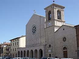
Bastia Umbra
Aspetto
| Bastia Umbra comune tagliàne | ||
|---|---|---|
 | ||
| ||
| State | ||
| Reggione | ||
| Provinge | ||
| Coordinate | 43°04′00″N 12°33′00″E | |
| Altitudine | 202 m s.l.m. | |
| Superficie | 27,62 km² | |
| Crestiàne | 21 360 (2007) | |
| Denzetà | 751,62 cr./km² | |
| Fraziune | Bastiola, Cipresso, Costano, Ospedalicchio, San Lorenzo | |
| Comune 'nzeccate | Assisi, Bettona, Perugia, Torgiano | |
| CAP | 06083 | |
| Prefisse | 075 | |
| Codece ISTAT | 054002 | |
| Cod. catastale | A710 | |
| Nome javetande | bastioli | |
| Patrone | San Michele Arcangelo | |
| Sciurne festive | 29 settembre | |
| Site istituzionale | ||
Bastia Umbra éte 'nu comune tagliáne de 19.471 crestiáne.
Categorije:
- Pagine con argomenti di formatnum non numerici
- Stub
- P625 uguale sus Uicchidate
- Prefisso telefonico locale uguale a Wikidata
- Codice ISTAT uguale a Wikidata
- P18 lette da Uicchidate
- P94 assende sus Uicchidate
- P281 uguale sus Uicchidate
- P806 uguale sus Uicchidate
- P856 uguale sus Uicchidate
- P2044 uguale sus Uicchidate
- P2046 differende sus Uicchidate
- Comune de l'Umbrie
- Comune d'a provinge de Perugge
- Pàggene cu le mappe

