
File:Map Italophone World - updated.png

Dimenziune de sta andeprime: 800 x 370 pixel. Otre resoluziune: 320 x 148 pixel • 640 x 296 pixel • 1 357 x 628 pixel.
File origgenale (1 357 × 628 pixel, dimenzione d'u fail: 55 KB, tipe de MIME: image/png)

|
Questa immagine (categorizzazione automatica: linguistic map) o tutte le immagini in questa categoria o galleria dovrebbero essere ricreate usando grafica vettoriale come file SVG. Questo offre diversi vantaggi: vedi Commons:Media for cleanup per maggiori informazioni. Se è disponibile una versione in formato SVG di questa immagine, per favore caricala. Dopo aver caricato un file SVG, sostituisci questo avviso con il template {{Vector version available|nome_immagine.svg}}.
|
Riepileghe
Map made from Image:BlankMap-World.png
| Descrizione |
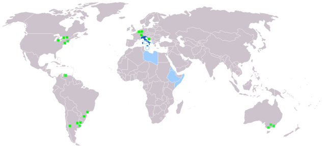
Deutsch: Legende:
Muttersprache
Amtssprache
Zweit- oder nicht offizielle Sprache
Italienischsprachige Minderheiten English: Legend:
Native language
Administrative language
Secondary language or non-official.
Italophone minorities Español: Leyenda:
Lengua materna
Lengua administrativa
Segunda lengua o lengua no oficial.
Minorías italofonas Français : Carte du monde où on parle l'italien.
Langue maternelle
Langue administrative
Langue importante et/ou langue de culture
Minorités italophones Italiano: Legenda:
Lingua madre
Lingua amministrativa
Seconda lingua o lingua non ufficiale
Minoranze italofone Português: Legenda:
Idioma materno
Idioma administrativo
Idioma secundário, ou não-oficial
Minorias italófonas Polski: Legenda:
Włoski jest językiem ojczystym
Włoski jest językiem urzędowym
Włoski jest drugim lub nieoficjalnym językiem
Mniejszości włoskojęzyczne |
| Sorgende | |
| Autore |
Licenziate da

|
Permesse jè garandite pe copià, distribbuì e/o cangià stu documende sotte a le termine d'a Licenze GNU Free Documentation, Versione 1.2 o versione cchiù nuève pubblecate da Free Software Foundation; senze le Seziune Invariande, senze Front-Cover Texts, e senze Back-Cover Texts. 'Na copie d'a licenze jè ingluse jndr'à sezione titolate Licenze GNU Free Documentation. |
| Stu file jè licenziate sotte 'a Creatività comune Attribution-Share Alike 3.0 Unported licenze | ||
| ||
| Stu tag de licenze ha state aggiunde a stu file cumme parte de l'aggiornamende d'a licenze GFDL. |
cunde
Cazze sus 'na date/orarie pe vedè 'u fail a cumme asseva jndr'à quidde timbe.
| Sciurne/Orarie | Thumbnail | Dimenziune | Utende | Commende | |
|---|---|---|---|---|---|
| corrende | 21:40, 27 Sce 2022 | | 1 357 × 628 (55 KB) | Jacob300 | Updated Somaliland - Italian was never an official language here |
| 20:25, 29 Lug 2021 |  | 1 357 × 628 (29 KB) | MMMM fan | Reverted to version as of 14:07, 3 July 2006 (UTC) Removing outdated or inaccurate Italophone minorities | |
| 11:36, 7 Mar 2018 |  | 1 357 × 628 (36 KB) | Maphobbyist | Montenegro and South Sudan borders | |
| 22:22, 5 Feb 2014 |  | 1 357 × 628 (39 KB) | Mr. Lama | {{SVG|map}} == {{int:filedesc}} == Map made from Image:BlankMap-World.png {{de|Legende: *Dunkelblau: Muttersprache *Blau: Amtssprache *Hellblau: Zweit- oder nicht offizielle Sprache *Grüne Quadrate: Italienischsprachige Minderheiten}} {{en|Lege... | |
| 16:07, 3 Lug 2006 |  | 1 357 × 628 (29 KB) | Fsolda~commonswiki | == Summary == Map made from Image:BlankMap-World.png {{en|Legend: *Dark blue: native language *Blue: administrative language *Light blue: Secondary language or non-official. *green square: italophone minorities}} {{es|Legenda: *azul oscuro: lengua |
Ause d'u file
Non ge stonne pàggene ca appodene a stu fail.
Ause d'u file globale
Le seguende Uicchi ausane stu file:
- Ause sus a ab.wikipedia.org
- Ause sus a en.wikipedia.org
- Ause sus a it.wikipedia.org
- Ause sus a lv.wikipedia.org
- Ause sus a nl.wikipedia.org
- Ause sus a pnb.wikipedia.org