
File:Arctic Ocean bathymetric features.png

Dimenziune de sta andeprime: 725 x 600 pixel. Otre resoluziune: 290 x 240 pixel • 581 x 480 pixel • 803 x 664 pixel.
File origgenale (803 × 664 pixel, dimenzione d'u fail: 664 KB, tipe de MIME: image/png)
Riepileghe
| Descrizione |
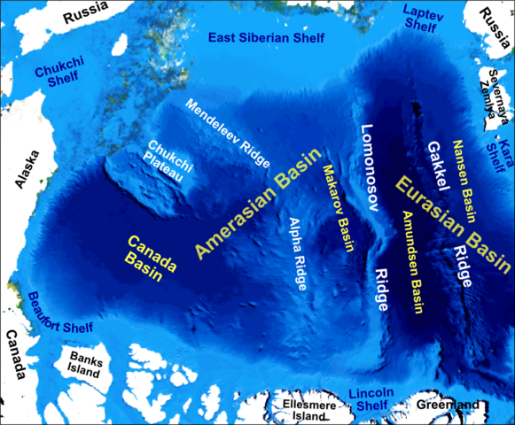
English: Main bathymetric features of the Arctic Ocean, taken mainly from Weber 1983 'Maps of the Arctic Basin Sea Floor: A History of Bathymetry and its Interpretation' on a base of a screenshot taken from the NASA WorldWind software |
| Date | |
| Sorgende | Fatije proprie |
| Autore | Mikenorton |
Licenziate da
Ije, 'u titolare d'u copyright de sta fatìe, dichiare de pubblecarle sotte 'a seguende licenze:
Stu file jè licenziate sotte 'a Creatività comune Attribution-Share Alike 3.0 Unported licenze
- Tu si libbere:
- da spartere – pe copià, distribbuì e trasmettere 'a fatìe
- da misckà – pe adattà a 'a fatìe
- Sotte a le condiziune seguende:
- attribbuzione – A dà le credite giuste, 'nu collegamende a 'a licenze e dicere ce onne state fatte de le cangiaminde. Puè farle accumme vuè tu, ma none jndr'à 'nu mode ca suggerisce ca 'u licenziande approve a te e l'ause tune.
- condivide cose simile – Ce tu cange, trasforme o costruisce sus a sta fatìe, tu puè destribbuì 'a fatìe ca ne iesse fore sule sotte a 'a stessa licenze o simile a queste.
cunde
Cazze sus 'na date/orarie pe vedè 'u fail a cumme asseva jndr'à quidde timbe.
| Sciurne/Orarie | Thumbnail | Dimenziune | Utende | Commende | |
|---|---|---|---|---|---|
| corrende | 02:12, 10 Nov 2012 | | 803 × 664 (664 KB) | Mikenorton | The 'Fram Basin' is now known as the 'Amundsen Basin' and the location of the two basins either side of the Gakkel Ridge has now been corrected |
| 13:21, 2 Ott 2011 |  | 2 408 × 1 993 (1,42 MB) | Mikenorton |
Ause d'u file
sta pàgene apponde a stu fail:
Ause d'u file globale
Le seguende Uicchi ausane stu file:
- Ause sus a ar.wikipedia.org
- Ause sus a az.wikipedia.org
- Ause sus a be.wikipedia.org
- Ause sus a ca.wikipedia.org
- Ause sus a cs.wikipedia.org
- Ause sus a de.wikipedia.org
- Ause sus a en.wikipedia.org
- Gakkel Ridge
- Lomonosov Ridge
- Litke Deep
- Mendeleev Ridge
- Alpha Ridge
- Siberian Shelf
- Eurasian Basin
- Amerasia Basin
- Chukchi Shelf
- Arctic Basin
- Arctic policy of Canada
- Talk:Arctic policy of Canada
- Canada Basin
- Makarov Basin
- Template:Did you know nominations/Geology of the Pacific Ocean
- Chukchi Plateau
- Gakkel Ridge Caldera
- Ause sus a en.wikiversity.org
- Ause sus a eo.wikipedia.org
- Ause sus a es.wikipedia.org
- Ause sus a fa.wikipedia.org
Vide ause globale de stu file.