
File:Yangtze River Map.png
Manghe 'a risoluzione ierta.
Yangtze_River_Map.png (576 × 355 pixel, dimenzione d'u fail: 123 KB, tipe de MIME: image/png)
Riepileghe
| Descrizione |
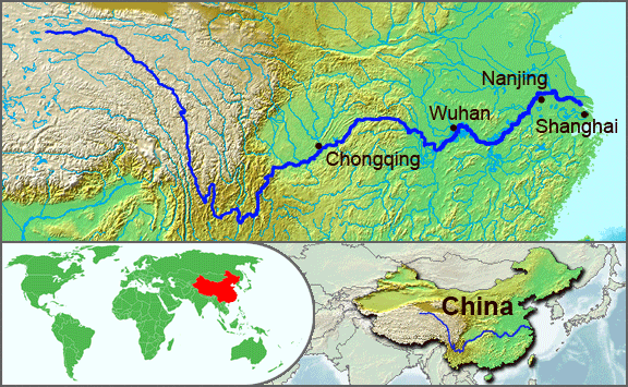
English: The underlying topographic maps used in this image come from the Demis Web Map Server, and are in the public domain. The world locator map is derived from :Image:BlankMap-World.png. I added the feature layers myself. —Papayoung ☯ 20:57, 1 October 2005 (UTC) |
| Date | 1 Ottòmmre 2005 (data di caricamento originaria) |
| Sorgende | Trasferito da en.wikipedia su Commons da Common Good utilizzando CommonsHelper. |
| Autore | L'utente che ha caricato in origine il file è stato Papayoung di Uicchipèdie in inglese |
| Otre versiune |
|
.JPG)
Licenziate da
| Stu file jè licenziate sotte 'a Creatività comune Attribution-Share Alike 3.0 Unported licenze Soggetto a disclaimer. | ||
| ||
| Stu tag de licenze ha state aggiunde a stu file cumme parte de l'aggiornamende d'a licenze GFDL. |

|
Permesse jè garandite pe copià, distribbuì e/o cangià stu documende sotte a le termine d'a Licenze GNU Free Documentation, Versione 1.2 o versione cchiù nuève pubblecate da Free Software Foundation; senze le Seziune Invariande, senze Front-Cover Texts, e senze Back-Cover Texts. 'Na copie d'a licenze jè ingluse jndr'à sezione titolate Licenze GNU Free Documentation. Soggetto a disclaimer. |
Archivije de le carecaminde origgenale
La pagina di descrizione originale era qui. Tutti i nomi utente che seguono sono riferiti a en.wikipedia.
- 2005-10-01 20:51 Papayoung 576×355× (125604 bytes) The underlying topographic maps used in this image come from the [http://www2.demis.nl/mapserver/mapper.asp Demis Web Map Server], and are in the public domain. The world locator map is derived from [[Commons:Image:BlankMap-World.png|BlankMap-World.png]].
- 2005-09-25 22:57 Papayoung 936×363× (221574 bytes) The underlying topographic maps used in this image come from the [http://www2.demis.nl/mapserver/mapper.asp Demis Web Map Server], and are in the public domain. I added the feature layers myself. —~~~~
cunde
Cazze sus 'na date/orarie pe vedè 'u fail a cumme asseva jndr'à quidde timbe.
| Sciurne/Orarie | Thumbnail | Dimenziune | Utende | Commende | |
|---|---|---|---|---|---|
| corrende | 22:30, 7 Màs 2009 | | 576 × 355 (123 KB) | File Upload Bot (Magnus Manske) | {{BotMoveToCommons|en.wikipedia|year={{subst:CURRENTYEAR}}|month={{subst:CURRENTMONTHNAME}}|day={{subst:CURRENTDAY}}}} {{Information |Description={{en|The underlying topographic maps used in this image come from the [http://www2.demis.nl/mapserver/mapper |
Ause d'u file
sta pàgene apponde a stu fail:
Ause d'u file globale
Le seguende Uicchi ausane stu file:
- Ause sus a af.wikipedia.org
- Ause sus a als.wikipedia.org
- Ause sus a am.wikipedia.org
- Ause sus a ary.wikipedia.org
- Ause sus a ast.wikipedia.org
- Ause sus a as.wikipedia.org
- Ause sus a azb.wikipedia.org
- Ause sus a be-tarask.wikipedia.org
- Ause sus a bh.wikipedia.org
- Ause sus a bn.wikipedia.org
- Ause sus a bo.wikipedia.org
- Ause sus a br.wikipedia.org
- Ause sus a cs.wikipedia.org
- Ause sus a de.wikipedia.org
- Ause sus a en.wikipedia.org
- Ause sus a en.wikinews.org
- Ause sus a es.wikipedia.org
- Ause sus a et.wikipedia.org
- Ause sus a eu.wikipedia.org
- Ause sus a fi.wikipedia.org
- Ause sus a fo.wikipedia.org
- Ause sus a frr.wikipedia.org
- Ause sus a fr.wikipedia.org
- Ause sus a fr.wikivoyage.org
- Ause sus a fr.wiktionary.org
- Ause sus a fy.wikipedia.org
- Ause sus a hi.wikipedia.org
- Ause sus a hu.wikipedia.org
- Ause sus a hy.wikipedia.org
- Ause sus a hyw.wikipedia.org
- Ause sus a id.wikipedia.org
- Ause sus a ilo.wikipedia.org
- Ause sus a incubator.wikimedia.org
- Ause sus a io.wikipedia.org
- Ause sus a it.wikipedia.org
- Ause sus a ja.wikipedia.org
- Ause sus a ka.wikipedia.org
- Ause sus a ko.wikipedia.org
- Ause sus a ku.wikipedia.org
- Ause sus a la.wikipedia.org
- Ause sus a lfn.wikipedia.org
Vide ause globale de stu file.