
File:NgareSero.jpg

Dimenziune de sta andeprime: 800 x 533 pixel. Otre resoluziune: 320 x 213 pixel • 640 x 427 pixel • 1 024 x 683 pixel • 1 280 x 853 pixel • 1 908 x 1 272 pixel.
File origgenale (1 908 × 1 272 pixel, dimenzione d'u fail: 1,08 MB, tipe de MIME: image/jpeg)
Riepileghe
| Descrizione |
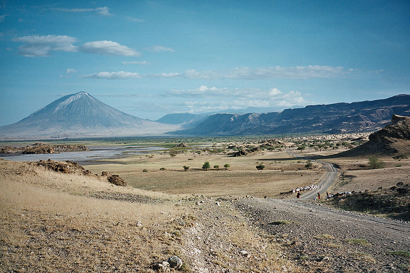
English: Landscape in Northern Tanzania, inside the great Rift valley. A dirt track is heading towards the Masaï village of Ngare Sero, 5 km south. The southern end of Lake Natron is visible on the left, the inner rim of the great rift on the right. The landscape is dominated by the huge Ol Doinyo Lengai volcano while the Ngorongoro highlands around Empaakai are visible in the background. |
| Date | Scattata il 6 Sciúgne 2006 |
| Sorgende | Fatije proprie |
| Autore | Clem23 |
Licenziate da
Ije, 'u titolare d'u copyright de sta fatìe, dichiare de pubblecarle sotte a le seguende licenze:

|
Permesse jè garandite pe copià, distribbuì e/o cangià stu documende sotte a le termine d'a Licenze GNU Free Documentation, Versione 1.2 o versione cchiù nuève pubblecate da Free Software Foundation; senze le Seziune Invariande, senze Front-Cover Texts, e senze Back-Cover Texts. 'Na copie d'a licenze jè ingluse jndr'à sezione titolate Licenze GNU Free Documentation. |
| Stu file jè licenziate sotte 'a Creatività comune Attribution-Share Alike 3.0 Unported licenze | ||
| ||
| Stu tag de licenze ha state aggiunde a stu file cumme parte de l'aggiornamende d'a licenze GFDL. |
Stu file jè licenziate sotte 'a licenze Creative Commons Attribution-Share Alike 2.5 Generiche, 2.0 Generiche, 2.0 Generiche e 1.0 Generiche
- Tu si libbere:
- da spartere – pe copià, distribbuì e trasmettere 'a fatìe
- da misckà – pe adattà a 'a fatìe
- Sotte a le condiziune seguende:
- attribbuzione – A dà le credite giuste, 'nu collegamende a 'a licenze e dicere ce onne state fatte de le cangiaminde. Puè farle accumme vuè tu, ma none jndr'à 'nu mode ca suggerisce ca 'u licenziande approve a te e l'ause tune.
- condivide cose simile – Ce tu cange, trasforme o costruisce sus a sta fatìe, tu puè destribbuì 'a fatìe ca ne iesse fore sule sotte a 'a stessa licenze o simile a queste.
Tu puè scacchià 'a licenze ca vuè.
cunde
Cazze sus 'na date/orarie pe vedè 'u fail a cumme asseva jndr'à quidde timbe.
| Sciurne/Orarie | Thumbnail | Dimenziune | Utende | Commende | |
|---|---|---|---|---|---|
| corrende | 12:32, 5 Sci 2007 | | 1 908 × 1 272 (1,08 MB) | Clem23 | {{Information |Description=Lanscape in Northern Tanzania, inside the great Rift valley. A dirt track is heading towards the Masaï village of Ngare Sero, 5 km south. The southern end of Lake Natron is visible on the left, the inner rim of the great rift o |
Ause d'u file
sta pàgene apponde a stu fail:
Ause d'u file globale
Le seguende Uicchi ausane stu file:
- Ause sus a ar.wikipedia.org
- Ause sus a azb.wikipedia.org
- Ause sus a bg.wikipedia.org
- Ause sus a de.wikipedia.org
- Ause sus a el.wikipedia.org
- Ause sus a fa.wikipedia.org
- Ause sus a fr.wikipedia.org
- Ause sus a hy.wikipedia.org
- Ause sus a id.wikipedia.org
- Ause sus a ja.wikipedia.org
- Ause sus a ki.wikipedia.org
- Ause sus a la.wikipedia.org
- Ause sus a pl.wikipedia.org
- Ause sus a ro.wikipedia.org
- Ause sus a ru.wikipedia.org
- Ause sus a sv.wikibooks.org
- Ause sus a tr.wikipedia.org
- Ause sus a uk.wikipedia.org
- Ause sus a vi.wikipedia.org